![](/images/other/stat-length.png)
![Excursión Senderismo Le Valtin - Schlucht Retournemer - Photo](https://media.geolcdn.com/t/1900/400/ext.pjpeg?maxdim=2&url=https%3A%2F%2Fstatic1.geolcdn.com%2Fsiteimages%2Fupload%2Ffiles%2F1553511878bg_sport_marche.png)
Schlucht Retournemer
vaillantjm
Usuario
![Longitud](/images/other/stat-length.png)
Longitud
17,2 km
![Altitud máxima](https://static1.geolcdn.com/siteimages/upload/files/1508320355ic_sort_altitude_max_24dp.png)
Altitud máxima
1294 m
![Desnivel positivo](https://static1.geolcdn.com/siteimages/upload/files/1508320355ic_sort_den_pos_24dp.png)
Desnivel positivo
957 m
![Km-Effort](/images/other/stat-length.png)
Km-Effort
30 km
![Altitud mínima](https://static1.geolcdn.com/siteimages/upload/files/1508320355ic_sort_altitude_min_24dp.png)
Altitud mínima
781 m
![Desnivel negativo](https://static1.geolcdn.com/siteimages/upload/files/1508320355ic_sort_den_neg_24dp.png)
Desnivel negativo
959 m
![Boucle](https://static1.geolcdn.com/siteimages/upload/files/16400158638029165_repeat_loop_refresh_sync_direction_icon.png)
Boucle
Sí
Fecha de creación :
2022-05-05 07:46:43.381
Última modificación :
2022-08-01 08:12:23.066
![Senderismo](https://static1.geolcdn.com/sitytour/trail-icons/101.png)
7h00
Dificultad : Muy difícil
![Escanee este código QR para abrir la excursión en la aplicación SityTrail](https://capi.geolives.com/qq0zvz2zws4bq2lad0pu/sitytour/trails/3230128/qr.png?size=200)
Aplicación GPS de excursión GRATIS
A propósito
Ruta Senderismo de 17,2 km a descubrir en Gran Este, Vosgos, Le Valtin. Esta ruta ha sido propuesta por vaillantjm.
Descripción
Le Sentier des Roches réclame beaucoup d'attention et commencera à entamer votre organisme. La montée du Falimont, et plus loin, celle de la Roche du Diable, sont bien rudes. Mais les vues en valent la peine.
Localización
País:
France
Región :
Gran Este
Departamento/provincia :
Vosgos
Municipio :
Le Valtin
Localidad:
Unknown
Salida:(Dec)
Salida:(UTM)
352703 ; 5325275 (32U) N.
Comentarios
Excursiones cerca
![Excursión Senderismo Le Valtin - Les Rochers des Hirschsteine - Lac Vert - Photo](https://media.geolcdn.com/t/375/260/4177d9e5-d8bc-4dac-ac45-c42f01ca30d3.jpg&format=jpg&maxdim=2)
![Senderismo Senderismo](https://static1.geolcdn.com/sitytour/trail-icons/101.png)
Les Rochers des Hirschsteine - Lac Vert
Senderismo
Difícil
(2)
Le Valtin,
Gran Este,
Vosgos,
France
![](/images/other/stat-length.png)
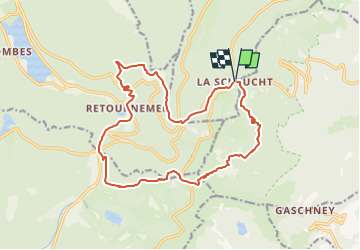
14,4 km | 22 km-effort
5h 2min
![](https://static1.geolcdn.com/siteimages/upload/files/16400158638029165_repeat_loop_refresh_sync_direction_icon.png)
Sí
![Excursión Senderismo Le Valtin - Col de la Schlucht - Photo](https://media.geolcdn.com/t/375/260/5b598871-c43c-4378-92fe-f06bddb4af29.jpg&format=jpg&maxdim=2)
![Senderismo Senderismo](https://static1.geolcdn.com/sitytour/trail-icons/101.png)
Col de la Schlucht
Senderismo
Muy fácil
(1)
Le Valtin,
Gran Este,
Vosgos,
France
![](/images/other/stat-length.png)
3,5 km | 5,2 km-effort
1h 17min
![](https://static1.geolcdn.com/siteimages/upload/files/16400158638029165_repeat_loop_refresh_sync_direction_icon.png)
Sí
![Excursión Senderismo Le Valtin - Le Sentier des Roches - Photo](https://media.geolcdn.com/t/375/260/f2737479-0e9e-43ec-9b66-c9706dc8ef91.jpg&format=jpg&maxdim=2)
![Senderismo Senderismo](https://static1.geolcdn.com/sitytour/trail-icons/101.png)
Le Sentier des Roches
Senderismo
Difícil
(2)
Le Valtin,
Gran Este,
Vosgos,
France
![](/images/other/stat-length.png)
20 km | 34 km-effort
7h 43min
![](https://static1.geolcdn.com/siteimages/upload/files/16400158638029165_repeat_loop_refresh_sync_direction_icon.png)
Sí
![Excursión Senderismo Stosswihr - Tour du belvedere avec le passage sur les crêtes - Photo](https://media.geolcdn.com/t/375/260/5b3c85c1-2643-45e9-9769-80e100e05dda.jpg&format=jpg&maxdim=2)
![Senderismo Senderismo](https://static1.geolcdn.com/sitytour/trail-icons/101.png)
Tour du belvedere avec le passage sur les crêtes
Senderismo
Muy fácil
(3)
Stosswihr,
Gran Este,
Alto Rin,
France
![](/images/other/stat-length.png)
8,5 km | 0 m-effort
2h 28min
![](https://static1.geolcdn.com/siteimages/upload/files/16400158638029165_repeat_loop_refresh_sync_direction_icon.png)
Sí
![Excursión Otra actividad Soultzeren - Totom 4 lacs - Photo](https://media.geolcdn.com/t/375/260/ext.jpg?maxdim=2&url=https%3A%2F%2Fservices.sitytrail.com%2FGeolivesWS%2FDownloadMedia.ashx%3FTrailID%3D789048%26Media%3D20170713134427.jpg)
![Otra actividad Otra actividad](https://static1.geolcdn.com/sitytour/trail-icons/900.png)
Totom 4 lacs
Otra actividad
Medio
(1)
Soultzeren,
Gran Este,
Alto Rin,
France
![](/images/other/stat-length.png)
15,6 km | 26 km-effort
4h 37min
![](https://static1.geolcdn.com/siteimages/upload/files/16400158638029165_repeat_loop_refresh_sync_direction_icon.png)
Sí
![Senderismo Senderismo](https://static1.geolcdn.com/sitytour/trail-icons/101.png)
Les 5 lacs autour du Hohneck
Senderismo
Muy difícil
(1)
La Bresse,
Gran Este,
Vosgos,
France
![](/images/other/stat-length.png)
21 km | 36 km-effort
7h 21min
![](https://static1.geolcdn.com/siteimages/upload/files/16400158638029165_repeat_loop_refresh_sync_direction_icon.png)
Sí
![Excursión Senderismo Le Valtin - Les Hirschsteine - Photo](https://media.geolcdn.com/t/375/260/ext.jpg?maxdim=2&url=https%3A%2F%2Fservices.sitytrail.com%2FGeolivesWS%2FDownloadMedia.ashx%3FTrailID%3D311037%26Media%3Dfix__20140608114301.jpg)
![Senderismo Senderismo](https://static1.geolcdn.com/sitytour/trail-icons/101.png)
Les Hirschsteine
Senderismo
Difícil
(1)
Le Valtin,
Gran Este,
Vosgos,
France
![](/images/other/stat-length.png)
16,1 km | 25 km-effort
6h 28min
![](https://static1.geolcdn.com/siteimages/upload/files/16400158638029165_repeat_loop_refresh_sync_direction_icon.png)
Sí
![Excursión Senderismo La Bresse - Du Hohneck au Kastelberg par les Spietzkoepfe et le Sentier des Névées - Photo](https://media.geolcdn.com/t/375/260/ext.jpg?maxdim=2&url=https%3A%2F%2Fservices.sitytrail.com%2FGeolivesWS%2FDownloadMedia.ashx%3FTrailID%3D110319%26Media%3D5746_5.jpg)
![Senderismo Senderismo](https://static1.geolcdn.com/sitytour/trail-icons/101.png)
Du Hohneck au Kastelberg par les Spietzkoepfe et le Sentier des Névées
Senderismo
Muy difícil
(3)
La Bresse,
Gran Este,
Vosgos,
France
![](/images/other/stat-length.png)
7,6 km | 13,7 km-effort
3h 30min
![](https://static1.geolcdn.com/siteimages/upload/files/16400158638029165_repeat_loop_refresh_sync_direction_icon.png)
Sí
![Excursión Senderismo Soultzeren - Tanet-Gazon du faing par lac vert et retour sommet du Tanet - Photo](https://media.geolcdn.com/t/375/260/ed68be74-246f-440b-833e-a0b4a96a4c20.jpg&format=jpg&maxdim=2)
![Senderismo Senderismo](https://static1.geolcdn.com/sitytour/trail-icons/101.png)
Tanet-Gazon du faing par lac vert et retour sommet du Tanet
Senderismo
Medio
(1)
Soultzeren,
Gran Este,
Alto Rin,
France
![](/images/other/stat-length.png)
10 km | 15,6 km-effort
4h 24min
![](https://static1.geolcdn.com/siteimages/upload/files/16400158638029165_repeat_loop_refresh_sync_direction_icon.png)
Sí